Thunderstorms, Lightning, Tornadoes, and Hurricanes

thunderstorm.jpg (15915 bytes) To make a thunderstorm we need three basic ingredients. The basic "fuel" is moisture (water vapor) in the lowest levels of the atmosphere. The air above the lowest levels has to cool off rapidly with height, so that 2-3 miles above the ground, it is very cold. Finally, we need something in the atmosphere to push that moist air from near the ground up to where the air around it is cold. This "something" could be a cold front or the boundary between where the cold air from one thunderstorm meets the air outside of the storm (called an outflow boundary) or anything else that forces the air at the ground together. When that happens the moist air is pushed up. What happens to a blob of moist air as it rises? It cools off and after a while, some of the water vapor turns into liquid drops (that we see as clouds). That warms up the rest of the air in the blob (the heat of vaporization is returned to us) so that it doesn't cool off as fast as it would if the air was dry. When that blob of air gets to the part of the atmosphere where it is very cold, it will be warmer and less dense than the air around it. Since it is less dense, it will start to rise faster without being pushed, just like a balloon filled with helium does. Then more water vapor turns into liquid in the blob and the blob warms up more and rises even faster until all of water vapor is gone and the blob eventually reaches a part of the atmosphere where it isn’t warmer than the environment (typically 5-10 miles).
Conditions in the atmosphere change a lot over a small distance in the vicinity of thunderstorms. Where the rain is falling, the pressure goes up by a few millibars (about 0.1 inches of mercury). This is because as the rain falls, some of it evaporates, which makes the air cooler and heavier. Another process is going on, however, that makes the picture complicated. As the air goes up in the thunderstorm’s updraft, it creates an area of low pressure under the updraft that acts to pull air in from around the thunderstorm. This low pressure region is also typically a few millibars lower than the environment of the storm. At the top of the storm the pressure is high compared to places far away from the storm and air is blown out.

Thunderstorms can be seen with a variety of tools. Radars let us see where rain and hail are located in the storm. Doppler radars also let us see how the wind is blowing within and near the storm. Some features of thunderstorms, such as the anvil-shaped cloud   that spreads out at the top of the storm, can be seen from satellites.

In the mood for some rain music?

lightning.jpg (16753 bytes) Lightning originates in parent cumulonimbus (thunderstorm) clouds around 15,000 to 25,000 feet above sea level, when raindrops are carried upward until some of them convert to ice. For reasons that are not widely agreed upon, a cloud-to-ground lightning flash originates in this mixed water and ice region. The charge then moves downward in 50-yard sections called step leaders. It keeps moving toward the ground in these steps and produces a channel along which charge is deposited. Eventually, it encounters something on the ground that is a good connection. The circuit is complete at that time, and the charge is lowered from cloud to ground.  The flow of charge (current) produces a luminosity that is very much brighter than the part that came down. This entire event usually takes less than half a second.
Flashes that do not strike the surface are called cloud flashes. They may be inside a cloud, travel from one part of a cloud to another, or from cloud to air.

Since the 1980s, cloud-to-ground lightning flashes have been detected and mapped in real time across the entire US by several networks. Over the continental 48 states, an average of 20,000,000 cloud-to-ground flashes have been detected every year since the lightning detection network covered all of the continental US in 1989. In addition, about half of all flashes have more than one ground strike point, so at least 30 million points on the ground are struck on the average each year in the US. Besides cloud-to-ground flashes, there are roughly 5 to 10 times as many cloud flashes as there are to ground.


tornado.jpg (13144 bytes)

And Dorothy says.....

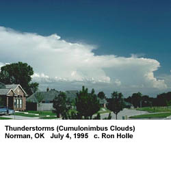
Tornadoes come from the energy released in a thunderstorm. As powerful as they are, tornadoes account for only a tiny fraction of the energy in a thunderstorm. What makes them dangerous is that their energy is concentrated in a small area, perhaps only a hundred yards across. Not all tornadoes are the same, of course, and science does not yet completely understand how part of a thunderstorm's energy sometimes gets focused into 
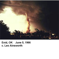
something as small as a tornado.  Whenever and wherever conditions are right, tornadoes are possible, but they are most common in the central plains of North America, east of the Rocky Mountains and west of the Appalachian Mountains. They occur mostly during the spring and summer; the tornado season comes early in the south and later in the north because spring comes later in the year as one moves northward. They usually occur during the late afternoon and early evening. However, they have been known to occur in every state in the United States, on any day of the year, and at any hour. They also occur in many other parts of the world, including Australia, Europe, Africa, Asia, and South America.
A look at the Ft. Worth/Arlington tornado from 3/27/2000.


hurr_bonnie98.jpg (20350 bytes) Hurricanes originate over warm oceans with water temperatures in the low to mid 80s (F), or warmer.  These conditions supply the warm moist air that fuels the clouds. They also need a way to flow the air toward the center (convergence) at low levels and remove the air aloft (divergence). When these conditions occur, pre-existing disturbances of many types can begin to organize into a tropical depression, then a tropical storm, then a hurricane.
In the North Atlantic Ocean, the classic mid-summer pattern for hurricane formation is in the low-level easterly trade-wind region from 10 to 20 degrees latitude north of the equator. Here, disturbances move westward from Africa several times a week that have the potential to strengthen. Before and after the mid-summer season, hurricanes form in the Gulf of Mexico, southern Caribbean Sea, and in the west Atlantic where several types of weather systems can form the necessary pattern of low-level inflow and upper-level outflow.