Seismic and the Earth's Structure
The structure of Earth's deep interior cannot be studied directly. But geologists use
seismic (earthquake) waves to determine the depths of layers of molten and
semi-molten material within Earth. Because different types of earthquake waves behave
differently when they encounter material in different states (for example,
molten, semi-molten, solid), seismic stations established around Earth detect and record
the strengths of the different types of waves and the directions from which
they came. Geologists use these records to establish the structure of Earth's interior.
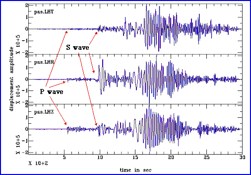
The two principal types of seismic waves are P-waves (pressure; goes through liquid and solid) and S-waves (shear or secondary; goes only through solid - not through liquid). The travel velocity of these two wave types is not the same (P-waves are faster than S-waves). Thus, if there is an earthquake somewhere, the first waves that arrive are P-waves. In essence, the gap in P-wave and S-wave arrival gives a first estimate of the distance to the earthquake.
Above image shows some typical seismograms with arrival of P- and S-waves marked.
As we know from physics, all waves change direction when they pass through layers of different density (refraction). That is what makes light collect in a magnifying glass, and that is also what makes seismic waves travel in curved paths through the Earth (because of the increasing pressure, materials are more dense towards the core, travel velocity of seismic waves increases). Refraction of seismic waves causes them to curve away from a direct path. Reflection causes them to glance off certain surfaces (e.g. core mantle boundary) when they hit it at too shallow of an angle. The result of this behavior, in combination with the fact that S-waves can not travel through liquids, is the appearance of seismic shadows, opposite of the actual earthquake site.
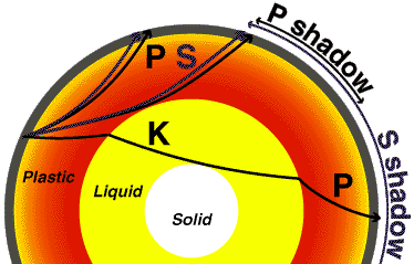
The geometric distribution and extent of these shadows as measured for a given earthquake (many receiver stations - seismographs, are needed all over the world to do that) allows us to calculate the position of major boundaries in the Earth's interior, as well as giving us information about the solid vs liquid character of the various layers, and even about some of their physical properties.
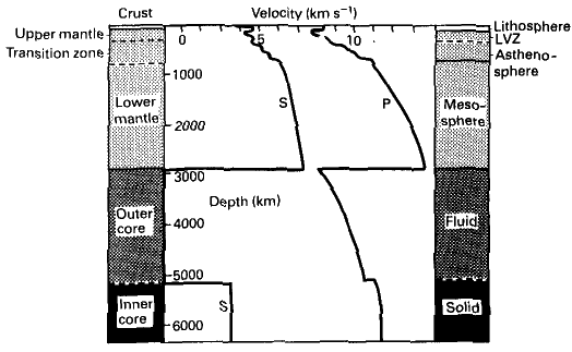
The biggest discontinuity in the Earth's interior is the core/mantle boundary, because there we have a strong density contrast between the iron core (density between 10-11 g/cm3) and the silicate mantle (density from 3.3-5.5 g/cm3, increases with depth).
Background sound is the actual recording of an earthquake.