Mars Rover Page
The two Mars Exploration Rovers (MER), Opportunity and Spirit, have been on Mars since January of 2004. Their most important finding was that there must have been abundant water on the Martian surface in the past. The waters certainly have filled shallow lake basins, but may also have formed entire ocean basins. A lot of the MER mission press releases have been posted on the following web site:
http://marsrovers.jpl.nasa.gov/home/index.html,
here is a link to a little movie clebrating the first year of the rovers: http://marsrovers.jpl.nasa.gov/gallery/video/movies/spirit/OneYearOnMars.mov
the key press release, pertaining to evidence for standing water, is posted here.
http://marsrovers.jpl.nasa.gov/newsroom/pressreleases/20040323a.html
this press release shows concretions that grew in sediment pore waters
http://marsrovers.jpl.nasa.gov/newsroom/pressreleases/20040318a.html
this press release was the first to show evidence for abundant salty water in pore spaces of sediments
http://marsrovers.jpl.nasa.gov/newsroom/pressreleases/20040302a.html
The following pictures show vistas of the Martian surface taken by the Opportunity Rover.
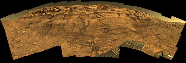
NASA's Mars Exploration Rover Opportunity captured this view of "Burns Cliff"
after driving right to the base of the southeastern portion of the inner wall of
"Endurance Crater." The view combines frames taken by Opportunity's panoramic
camera between the rover's 287th and 294th martian days (Nov. 13 to 20, 2004).
This is a composite of 46 different images, each acquired in seven different
Pancam filters. It is an approximately true-color rendering generated from the
panoramic camera's 750-nanometer, 530-nanometer and 430-nanometer filters. The
mosaic spans more than 180 degrees side to side. Because of this wide-angle
view, the cliff walls appear to bulge out toward the camera. In reality the
walls form a gently curving, continuous surface.
Opportunity safely exited Endurance Crater on December 12, 2004 (sol 315) after
a six-month investigation inside. Opportunity is once again on the plains of
Meridiani Planum and will attempt to travel farther into the unknown.
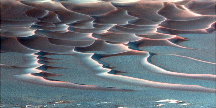
8/6/2004 As NASA's Mars Exploration Rover Opportunity crept farther into
"Endurance Crater," the dune field on the crater floor appeared even more
dramatic. This false-color image taken by the rover's panoramic camera shows
that the dune crests accumulated more dust than the flanks of the dunes and the
flat surfaces between them. Also evident is a "blue" tint on the flat surfaces
as compared to the dune flanks. This results from the presence of the
hematite-containing spherules ("blueberries") that accumulate on the flat
surfaces.
Sinuous tendrils of sand less than 1 meter (3.3 feet) high extend from the main
dune field toward the rover. Scientists wanted to send the rover down to one of
these tendrils in an effort to learn more about the characteristics of the
dunes. Dunes are a common feature across the surface of Mars, and knowledge
gleaned from investigating the Endurance dunes close-up may have applied to
similar dunes elsewhere. Rover drivers discovered that the slippery slope that
led to the dunes was not firm enough to ensure a successful drive back out of
the crater, and the dune field may have been a true sand trap, so Opportunity
ultimately did not cruise around too close to the dunes.
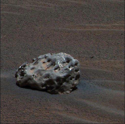
Iron Meteorite
on Mars
NASA's Mars Exploration Rover Opportunity has found an iron meteorite on
Mars, the first meteorite of any type ever identified on another planet. The
pitted, basketball-size object is mostly made of iron and nickel. Readings from
spectrometers on the rover determined that composition. Opportunity used its
panoramic camera to take the images used in this approximately true-color
composite on the rover's 339th martian day, or sol (Jan. 6, 2005).